

New technology called “Virtual Fencing” is catching on in Idaho and the West.
Virtual Fencing works like an invisible fence for pets but at a much larger scale for livestock management.
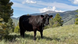
“I think it’s been really beneficial and almost fun to get to do this and learn about it. It’s been a helpful tool, all in all,” said Chyenne Smith, who with her husband, Jay, runs J Lazy S Ranch in Carmen Creek, Idaho, near Salmon.
“My wife’s happy, my cows are doing good, the range is managed well, the forest and the BLM are happy, and our calf weights are up, and the markets good, how do you do any better than that?” added Jay Smith.
Virtual Fencing software allows producers and support teams to draw boundaries where they want livestock to graze. (Image courtesy Joel Yelich, University of Idaho)
Jay and Chyenne Smith worked with a research team at the University of Idaho, the Salmon-Challis National Forest and Bureau of Land Management to set up a Virtual Fencing project on spring, summer and fall range.
The project really shined in allowing the Smiths to graze cattle in the Diamond-Moose Allotment in the Salmon-Challis National Forest just one year after the massive Moose wildfire.
“After the Moose Fire, the standard Forest Service answer is to stay home for 2-3 years,” said Jay Smith. “We went up there and did a self-survey, in the fall of ‘22, we could see with our own eyes that approximately 40,000 of the very best acres were unburned or lightly burned. With that much good forage, staying home for 2-3 years did not feel like the right answer to me.”
“So I reached out to the University of Idaho, and I said, hey, maybe this is the right time to negotiate a deal to not leave all that grass on the table.”
GPS collars on mother cows transmit data to base station towers to inform producers where their cows are grazing on private or public lands.
The Smiths also wanted to capitalize on the lucrative cattle prices in 2023 and 2024, meaning they needed to find places to graze their cattle herds on public lands, despite the Moose Fire. “If we would have had to sell those cows, we would have missed the peak market,” Smith said.
Turns out, the University of Idaho was eager to support the Virtual Fencing project. Joel Yelich, a Ph.D. Senior Livestock Researcher at the Nancy M. Cummings Research, Extension and Education Center in Salmon, jumped in with both feet.
“Not only did they have professional staff and knowledge-base to help us get going and manage the Virtual Fences, they had the connections, time and resources to help us apply for grants and get funding. We would not have been able to do this without the University of Idaho,” Smith said.
The Forest Service and Bureau of Land Management also were helpful by investing in Virtual Fencing base stations to assist in the project. Base stations cost about $10,000 each.
“I’d say things are going quite well,” said Kyle Nelson, Rangeland Management Specialist for the Salmon-Challis National Forest. “Our first season, we went into it with a lot of unknowns, pretty steep learning curve, and we’ve been able to take what we learned last year and use that with our implementation this year.”
Linda Price, Manager of the BLM Salmon Field Office, agreed.
“I think it’s going great,” she said. “When I’m talking to permittees who are part of this, I’m hearing a lot of positive things.”
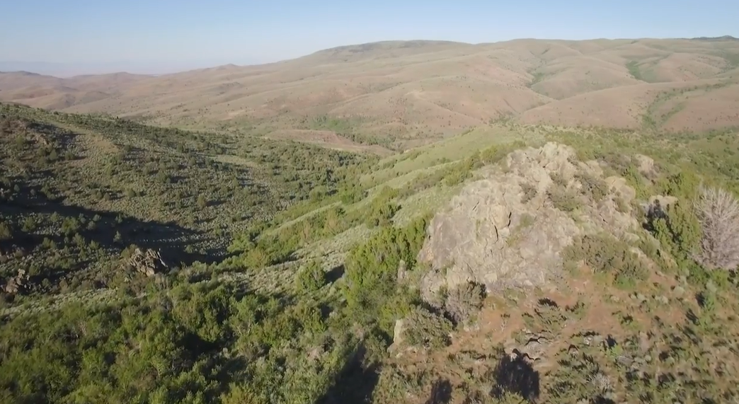
One limitation with Virtual Fencing technology currently is that a strong cell signal is needed for it to function correctly, ruling out a number of remote locations in Idaho. (photo by Chris Ennis/LOTR)
That said, Virtual Fencing technology has limitations, currently. For example, it won’t work in remote areas outside of cellular range. That rules out a lot of remote rangelands in Idaho.
Ranchers who already have fenced pastures on state or federal grazing allotments won’t need it. But Virtual Fencing may be valuable for controlling livestock in rugged areas where building fence is cost-prohibitive.
History and Creation of Virtual Fencing Technology
Let’s take a moment to review the history. Who invented Virtual Fencing technology? How does it work? What are the benefits?
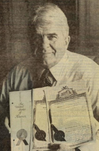
Richard Peck, founder of the Invisible Fence for pets, shows the patents he received for that technology.What are the benefits?
Richard Peck, a traveling salesman, received the patent for inventing “Invisible Fencing” technology for pets in 1971.
Dr. Dean Anderson, a Range Scientist in New Mexico, worked together with Dr. Daniela Rus, Director of the Artificial Intelligence Lab at MIT, to develop Virtual Fencing technology.
Jasper Holdsworth, a New Zealand rancher who wanted to create rest-rotation systems without fencing, partnered with Vence co-founder Frank Wooten to make the technology more commercially feasible.
Vence provides the herd-management software and base station interface technology for the Virtual Fencing system in Salmon.
Virtual Fencing systems have three basic components:
- A base station, typically solar powered, in a place where it can receive a strong cellular signal from an existing network.
- Vence GPS collars are placed on livestock.
- Grazing boundaries are set with Vence herd-management software.
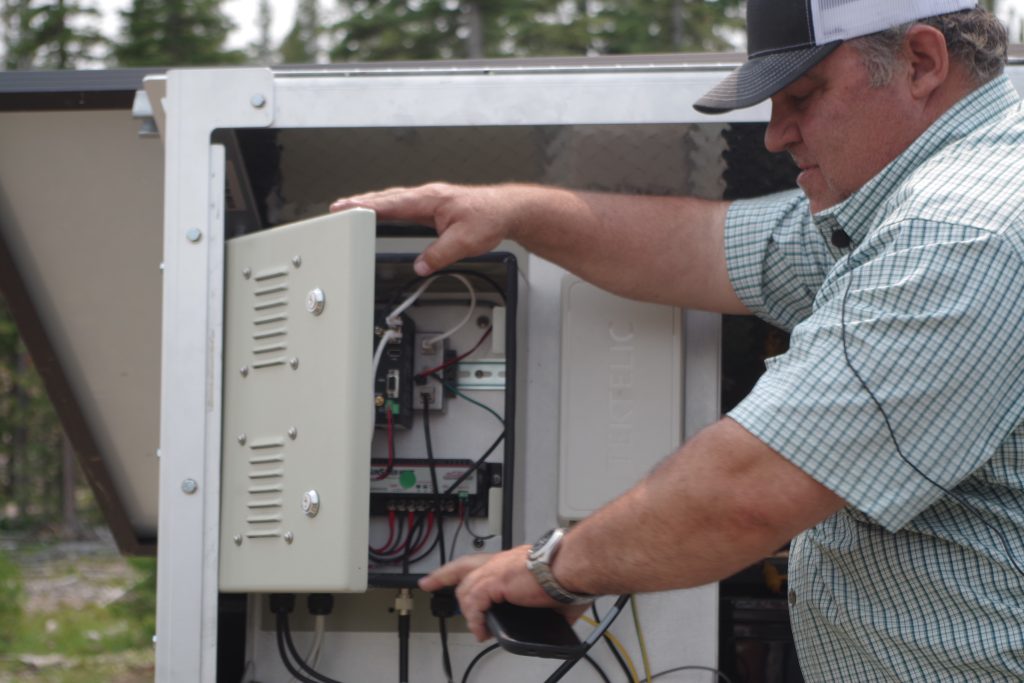
Joel Yelich, a Ph.D. range scientist with the University of Idaho Nancy M. Cummings Research and Education Center, provides peek inside a Virtual Fencing base station. (photo by Steve Stuebner/LOTR)
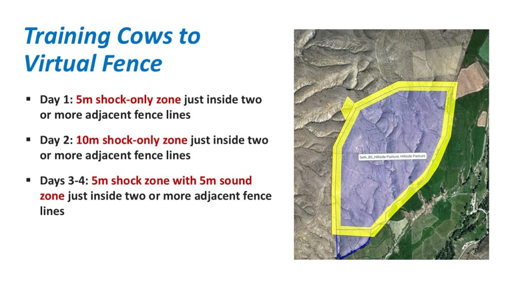
To get started, it takes 4-5 days to train the cattle in a small pasture so they learn to respect the Virtual Fence boundaries.
Joel Yelich explains.
“We initially set up a barrier that’s 5-10 meters away from the physical fence,” Yelich says. “When the cows hit that virtual zone, they get a shock. The first day is strictly shock.”
“Second day, we go through a larger zone of shock 15-20 meters, and then the third day we go to a combination of the shock and sound. They hit the sound and then the shock, and the sound is reinforcing that they’ll be going into a shock zone next.”
 The Life on the Range video shows a mother cow responding to an audio cue and turning away from the virtual fence boundary.
Only mother cows have GPS collars on them, assuming their calves will generally stay with them on the range.
How it works illustration (courtesy Conservation Northwest)
Yelich works with Vence technicians to set up multiple base stations on Forest Service and BLM lands to provide broad coverage in steep, mountainous terrain. Vence technicians check on the coverage with a radio frequency scan.
“And then what you try to do is, figure out where you need to put enough towers to get adequate coverage of your entire allotment,” Yelich said.
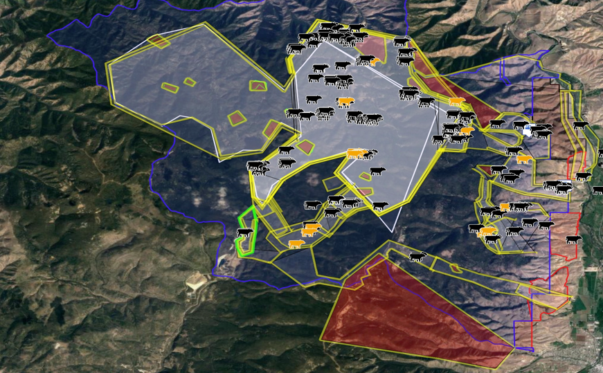
Turns out, it took five base stations to provide coverage of the 60,000-acre Diamond-Moose Allotment and BLM lands on the opposite side of the Salmon Valley.
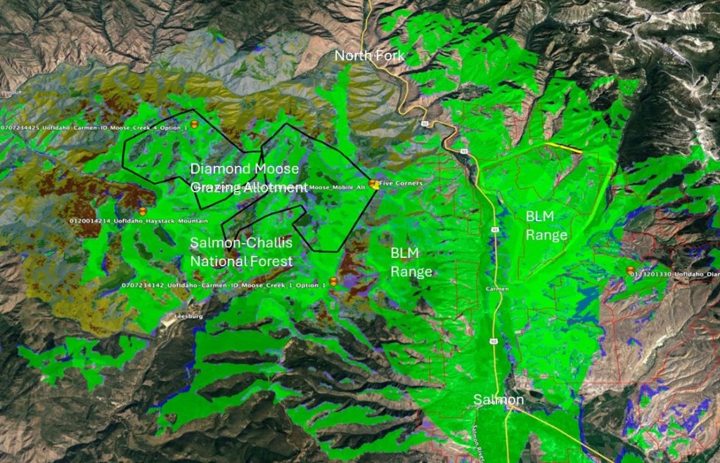
Five base stations were stationed at high-elevation strategic points in the Salmon-Challis National Forest and on BLM lands to cover the spring, summer and fall range areas for the Smiths and several other permittees. (courtesy Joel Yelich, University of Idaho)
“The tower operates off a cell signal, and it operates off of Lorawan, a commonly used radio interface – it’s a free signal and can transmit data to the Internet,” Yelich says.
“That cellular signal is typically line of sight, and it goes to the nearest tower you have, that allows the base station to communicate with the cloud, that contains all the information that’s downloaded on each cow.”
“So then, what you can do is get into the software, each permittee, has their cows and a herd, and each herd has a separate color, and then the permittees can see where their cows are at.”
That’s where the time-savings comes in. If a rancher sees that a cow is moving out of the Virtual Fence pasture, they can create a second Virtual Fence to encourage the mother cow to move back into the pasture.
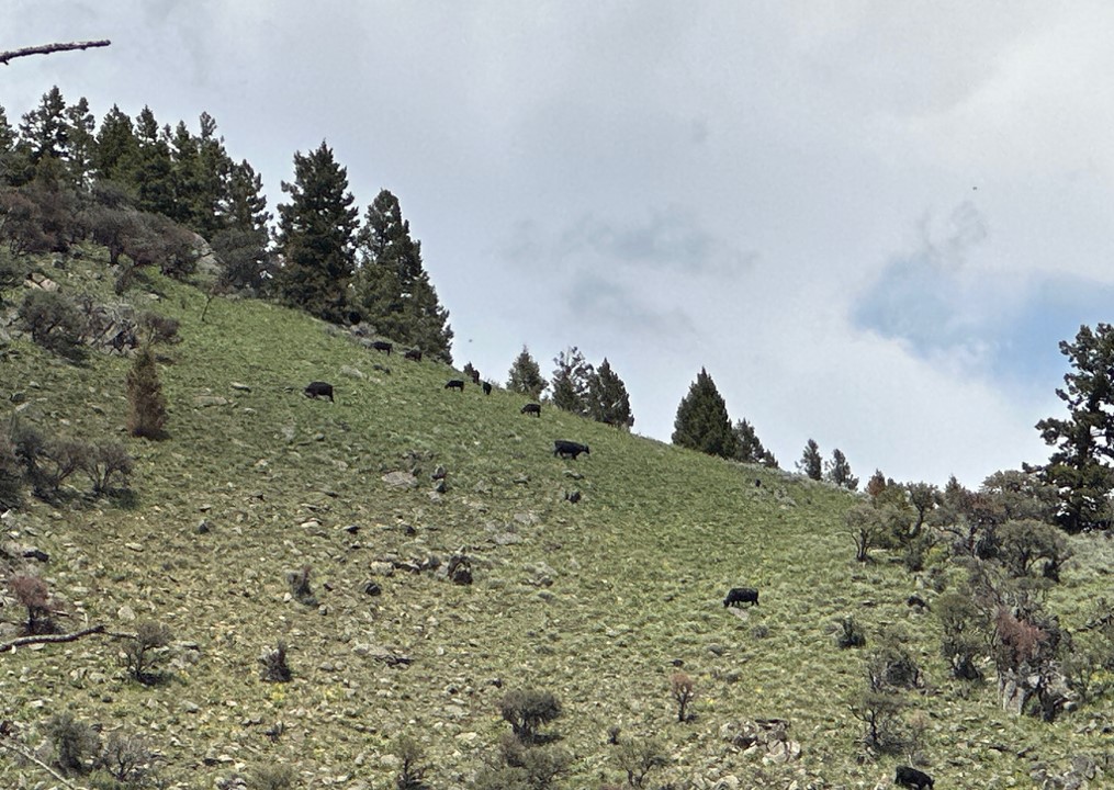
Virtual Fences helped keep cattle focused on feeding in the right areas on spring, summer and fall range, leading to more consistent use of rangelands, the Smiths said.

Ranchers can create a second virtual fence boundary to entice strays to return to the proper pasture.
If she doesn’t respond correctly, the rancher knows exactly where the cow is located, shortening the trip to herd them back into the right pasture.
“Yes, incredible amount of time saved,” says Chyenne Smith. “Last year, it cut down my emergency rides by 95%.”
Smith notes that the GPS cattle data is shared only with producers, not the agencies.
“There’s been some concern about the scientific data that the cows collect and who gets that,” she said. “Vence only gives that data to the ranchers. The government doesn’t get it.”
The Virtual Fences only provide shock in one direction – if the cows try to leave the pasture boundary. There is no shock if they return to the right pasture.
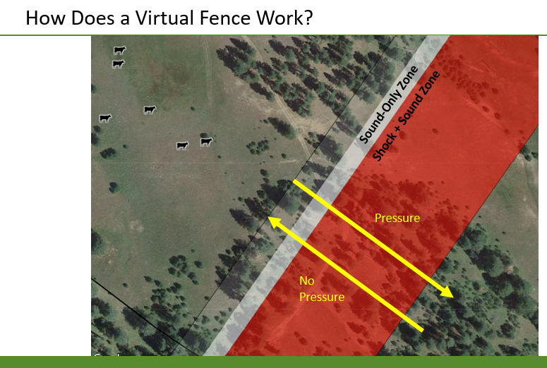
Livestock only receive a tone and shock if they try to move behind the Virtual Fence boundary. There is no shock to re-enter the correct pasture.
The Virtual Fencing technology appealed to the Smiths not only to keep their cattle in areas suitable for grazing post-fire, but they never had fences on the west side of their spring and summer range. Each year, some cows strayed from where they were supposed to be.
“We spent a lot of time making sure those cows weren’t getting in trouble,” she says.
Now, she’s riding more for fun.

The Smith Family at the J Lazy S Ranch in Carmen Creek, Idaho.
“I got to do some things I wanted to do – I broke a horse last year, I haven’t broken a horse since I was a teenager, I had time to do other things than just going and chasing bad cows,” she says.
Virtual Fencing pastures have led to more even consumption of forage on public lands, too.
“Yes, way better,” Chyenne Smith says. “Virtual fence kept all the cows exactly where they were supposed to be, which was beneficial to the range in so many ways. The bottom part of the range got a rest, (from end of spring grazing till fall), that grass went bonkers.
“The middle part of the range, which we have never been able to substantially use, because you’re fighting both ends, it got cows on it and got grazed so it shouldn’t be a fire hazard.
“Then the top of the mountain, that range was huge, there was so much grass, the cows could barely touch it by the time they got up there, which is beneficial to the range and the wildlife and all of the things.”

Virtual Fences helped protect post-burn riparian areas in the Moose Fire zone, according to the Forest Service officials. They kept track of protecting sensitive areas post-fire with range-monitoring work. (courtesy Salmon-Challis N.F.)
Forest Service officials agreed that range utilization improved with Virtual Fencing. They checked on summer range pastures and took photos of the range use.
“We didn’t have over-utilization, we had good distribution, things were looking good out there,” Nelson said.
“Our riparian areas inside those grazing units were on par with our uplands, in good condition, so yeah. Those riparian areas are even more sensitive post-fire, so being able to exclude those provided a real benefit,” he said.
The Virtual fencing software gave the Smith’s a head’s up when predators or other factors spooked livestock. She shows an example of the cattle running downhill, trying to escape something.
“You can see in real time that the cows are scattering for whatever reason, one reason was they were doing helicopter training, and our cows scattered,” she said.
Herding is still needed at times like that, but the GPS data show where to find the cattle. “Knowing where they were gave us so much peace of mind,” she said.
Virtual Fencing does not eliminate the need for perimeter boundary fences. “It’s not a perimeter fence. So where it really works is all of those interior fences, when you’re trying to go from pasture to pasture,” Yelich says.
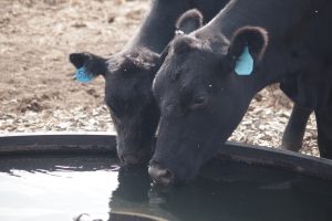
A water source must be available in Virtual Fencing pastures or cattle may venture off to find water on their own.
Virtual Fence pastures also must have a water source.
“That’s the real challenge is understanding where your water is,” Yelich says. “That’s going to dictate where you can put virtual fences. If you have scenarios where cows don’t have any water, and they know where to get water, and they’re fenced out, they’re going to go through the Virtual Fence.
“They’ve got to have water.”
Smith recommends that other ranchers may want to try Virtual Fencing if could fit their operations and range management objectives.
“We were absolutely astounded by how helpful it was, how beneficial it was for the range, for our cattle, for our workload, it seems like it would be something that’s super useful for just about anybody, however they wanted to use it,” she says.
Elsewhere in the West, Virtual Fencing has been used to protect riparian areas, create fuel breaks, rest-rotation grazing and more – all without physical fences.
Lane Justus, Idaho Resources Coordinator for the Western Landowners Alliance, has toured a number of Virtual Fencing projects and likes the results.
“Yeah, Jay and Chyenne have a really cool project where they use virtual fencing post-fire, so they can still graze an area that has eligible AUMs, and avoid burned areas and sensitive areas, so it’s really awesome,” Justus said.

Lane Justus with the Western Landowners Alliance.
“One of the reasons they’ve been so successful is because they have the support of the University of Idaho to draw the fence lines, helps them manage the land in a way they do such a good job at.
“Overall, it’s a really cool tool that can be used for numerous things, it’s an adaptive tool, that can address riparian restoration, can address large carnivore conflicts, can address wildfire, grazing techniques and tools, However, it’s still a very new technology.
“If we’re investing in the tool, we need to also invest in the technological support that goes along with it.”
“My brain goes crazy with the opportunity,” Price says. “Your imagination is the only thing that limits it. As the technology improves and the collars get better and the electronics get less expensive, I think we’re going to see a lot more people participating.”
In terms of costs, the Smiths say it’s worth the money to invest in the GPS collars at $50 each, but it definitely helps to find grants for the cost of the base stations (approximately $10,000 each). Individual ranchers could not afford to shoulder the costs of base stations alone, especially if several are needed.
“We’re very fortunate to be part of the pilot project, got some grants, and made this more affordable,” Jay Smith said. “And then hopefully our data and our usage makes it more popular, makes the cost go down, makes the product better. Definitely our goal, in being pioneers in this, is to help it benefit more people in the future.”
Steve Stuebner is the writer and producer of Life on the Range, a public education project sponsored by the Idaho Rangeland Resources Commission.
© 2024